Approximately 1000 miles of freeway shoulders are open to cyclists in California. Although a freeway is often a last choice for cyclists, access is necessary (and generally safe, see our position paper on freeway access) for bicycle travel, especially in the desert portions of the state where there are no alternate routes. However, generally speaking, whenever there is an alternate route, cyclists must exit the freeway and use that route instead – even in rural areas. This policy is more restrictive than freeway access in Arizona, for example (which only limits freeway access in urban areas), and can be confusing to cyclists since many of these alternate routes are not shown on conventional maps.
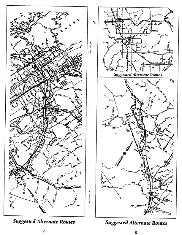
A few of these are major routes for long distance touring cyclists through the Southern California deserts: I-8, I-10, I-15, and I-40 (old Route 66) . A District 8 Bicycling Map (for Riverside County and San Bernardino County) wass available from Caltrans (link to scanned 1.2 MB PDF file) showing which portions of I-10, I-15, and I-40 are legal for cyclists, along with alternate routes where freeway access is prohibited. This map is somewhat dated (January 1992) and is difficult to read. Therefore, based on the District 8 map, we have provided a narrative description of the freeway segments open to cyclists and alternate routes shown on the map. The suggested alternate routes are taken directly from the map (and adjusted based on latest information) and therefore are not necessarily routes recommended or tested by CABO.
Also, the route on I-5 is included between San Clemente in Orange County to Oceanside in San Diego County, since the normal alternate route through Camp Pendleton Marine Base can be closed to cyclists on occasion.
Directions are given from north to south along the coast, and west to east inland, as those seem to be the more popular directions for long distance tourists. Exit numbers shown below are from the new Caltrans mileage based exit numbering system.
Finally, be advised that services are very limited in the Mojave Desert – be sure to carry plenty of water and food!
I-5, San Clemente (Orange County) to San Diego, north to south
- Bicycles OK from Las Pulgas Road (Exit 62) to Oceanside Harbor Dr. (Exit 54C). Bicyclists must exit at the rest stop, cycle through the rest stop, and then reenter the freeway at the other end. Directions and pictures from the Amtrak Century page.
- For detailed directions see Bicycling on Old US 101 in San Diego County.
- Also, most of this route is covered in the Pacific Coast Route Maps from Adventure Cycling.
I-8, entire length, west to east
- For detailed directions see Bicycling on Old US 80 in San Diego County.
- Also, most of this route is covered in the Southern Tier Route Maps from Adventure Cycling.
I-10 (Under Construction)
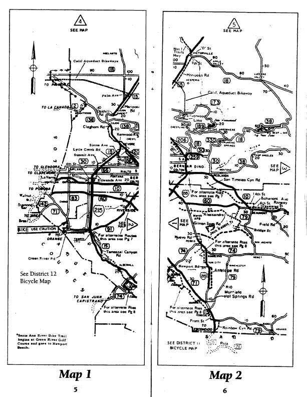
I-15, entire length, south to north (Maps 1 and 2, Map 5, Map 7, and suggested alternate routes)
- For the San Diego to Temecula (near the Riverside County Line) see Bicycling on Old US 395 in San Diego County.
- Alternate route from Temecula in Riverside County to the Cajon Pass in San Bernardino County
- From northbound Rainbow Canyon Rd., take a left (west) on Pala Rd.
- Left (west) on Highway 79
- Cross under I-15
- Highway 79 uses the freeway, stay on the road you’re on (Old Town Front St.)
- Old Town Front St. becomes Jefferson Ave.
- Left (southwest) on Ivy St./Los Alamos Rd. in Murrieta
- Right (northwest) on Washington Ave.
- Washington Ave. becomes Palomar St.
- Bear right (north) on Mission Tr. in Wildomar
- Mission Tr. becomes Lakeshore Dr. in Lake Elsinore
- Lakeshore Dr. becomes Main St.
- Left (west) on W. Graham Ave.
- W. Graham Ave. becomes Lakeshore Dr.
- Cross Riverside Dr./CA 74 (optional turnoff to Orange County)
- Right (north) on Lake St.
- Left (northwest) on Temescal Canyon Road (just before I-15 ramps)
- Temescal Canyon becomes Ontario Ave in the city of Corona
- Right (north) on Main St.
- Main St. becomes Hamner Ave. in Norco
- Hamner Ave. becomes Milliken Ave. in Ontario (after crossing under CA 60)
- Right (east) on 4th St. (after crossing under I-10)
- Left (north) on Etiwanda Ave. (after crossing under I-15)
- Right (east) on Banyan St. in Rancho Cucamonga (after crossing under CA 210)
- Right (east) on Wilson Ave.
- Left (north) on Cherry Ave. in Fontana
- Right (east) on Bridlepath Dr.
- Bridlepath Dr. becomes Duncan Canyon Rd. – now the route is parallel to I-15 again
- Left (northeast) on Lytle Creek Rd.
- Left (north) on Sierra Ave.
- Right (east) on Glen Helen Pkwy.
- Cross freeway twice
- Glen Helen Pkwy. becomes Devore Rd.
- Left (west) on Kenwood Ave.
- Cross under I-15
- Right (northwest) on Cajon Blvd.
- Cajon Blvd. ends at Cleghorn Rd.
- Bicycles OK from Cleghorn Rd. (Exit 129) to Oak Hill Rd. (Exit 138)
- Alternate Route to Barstow
- Mariposa Rd. parallels east side of freeway
- At end of Mariposa Rd. take a right on 7th Street (old 66)
- Downtown Victorville
- Left on D Street (old 66)
- After crossing under freeway, becomes National Trails Highway (old 66)
- National Trails Highway becomes Main St. near Barstow
- Left on N. 1st Ave. (another choice is to stay on Main St. and use I-40 directions below, returning near I-15 on Daggett-Yermo Rd.)
- N. 1st Ave. becomes Old Highway 58
- Bicycles OK from Old Highway 58 (Exit 186) to Fort Irwin Rd. (Exit 189)
- The map indicates that the freeway may be open from Fort Irwin Rd. (Exit 189) to Field Rd. (Exit 213), but this appears to be an error. But there is an alternate route shown on the map:
- Yermo Rd.
- Cross Daggett-Yermo Rd. (go south on this if you want to follow I-40)
- Continue on Yermo Rd.
- Left on Field Rd. to freeway ramp
- Bicycles OK from Field Rd. (Exit 213) to W. Baker (Exit 245)
- Alternate Route – Baker Blvd.
- Bicycles OK from E. Baker (Exit 248) to Nevada State Line
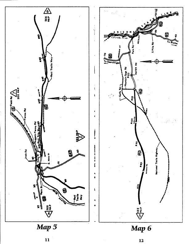
I-40, entire length, west to east (Maps 5 and 6)
- Alternate Route through Barstow: Main St.
- Bicycles OK from E. Main (Exit 2) to Nebo St. (Exit 5)
- Alternate Route
- National Trails Highway
- Cross Daggett-Yermo Rd. (go north on this if you want to follow I-15)
- Continue on National Trails Highway through Newberry, Ludlow, Essex
- Left (northeast) on Goffs Rd.
- Cross I-40 (big gas station, only services around for miles)
- Right (south) on US 95
- Bicycles OK from US 95 (Exit 133) to River Road (Exit 139) (Park St. on Caltrans map)
- Alternate Route through Needles
- Park St.
- Right on Needles Hwy./River Rd.
- Cross under freeway twice
- Right on Broadway
- After crossing under freeway, becomes US 95
- Left on Five Mile Road
- Bicycles OK from Five Mile Rd. (Exit 148) to Arizona State Line